Aircraft, including both helicopter and airplanes, can be effectively used to obtain deer density, sex ratios, fawn survival, and deer distribution information in some portions of the US. Although more expensive to conduct than the spotlight and mobile deer surveys, the aerial survey does provide the necessary population data in a short time frame. This information can be utilized to provide harvest recommendations for the entire ranch, as well as individual pastures. So, does a helicopter survey make sense for your deer management program?
The helicopter survey is considered by some to be the most accurate census for determining populations on a given unit of land. However, the total number of deer recorded on helicopter surveys should not be considered a complete count of all deer. Studies indicate that accuracy of helicopter surveys in South Texas brushland is fairly consistent, but they can underestimate deer density by 60-70%!
As a result, the information gathered from this type of survey should be used only as population trend information and for the preparation of annual harvest recommendations with the understanding that the deer density figures are probably conservative.
Helicopter Surveys
For aerial surveys using a helicopter, surveys should start approximately 15 to 30 minutes after sunrise. On ranches with dense vegetation and/or hills, it is recommended to start at least an hour or more after sunrise due to shadows. Of course, the drawback to starting later is that deer movement is reduced — so you need to keep some of these factors in mind and make sure that survey techniques are consistent over time.
On smaller ranches, or those located in open country, the entire ranch can be surveyed rather than sampled. The survey should be flown by pasture because this provides shorter transects and a good flight line can be maintained. Most often aerial surveys are conducted with both a pilot and an observer with each counting the deer observed.
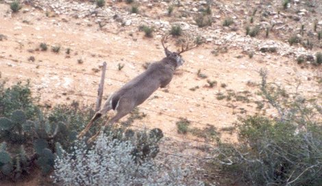
The observer records all bucks, does, fawns and any unidentified deer spotted. This data should be recorded on a data sheet rather than a tape recorder as information may be lost due to tape malfunction or garbled due to aircraft noise. Data should be collected by pasture if a complete ranch survey is being conducted.
The observer may also record bucks by point-class (2-3, 4-7, 8-9, or 10+ points) to provide additional information. However, I wouldn’t suggest flying off from the transect to collect this information. If data is collected in this manner, then you can establish harvest ecommendations by pasture. This is an important consideration if the landowner or manager is leasing by pastures to several groups or otherwise needs to manage the harvest by pasture.
Ideally, transects should be flown on north-south bearings. This eliminates the observer and pilot from looking directly into the sun and missing deer. This is not always practical due to terrain or other obstacles that may be in the flight path. Another consideration is wind direction. Helicopter pilots prefer to fly into the wind when possible and the wind does not always blow from the north or south. Survey altitude will normally be from 30-50 feet above ground level. Flight altitude is also dependent upon terrain, vegetation condition, type, composition and any manmade obstacles that occur on the ranch.
Difficulties in locating and counting deer can be expected where heavy, close-growing stands of cedar, oaks and/or a combination of tall over story of trees with heavy brush undergrowth. Aerial surveys may not be suitable on ranches that have near complete canopy closure of evergreen species that reach heights of 10-15 feet. Shin oak, open ranches, or brush country is not as problematic because running deer are still readily visible.
In dense vegetation, deer will not readily move from the sound of the helicopter. For individual pastures it is better to initiate the count in the densest portion of the pasture and work toward the more open areas. Likewise the hillsides should either be worked from top to bottom or bottom to top depending on location of open areas.
Actually Counting
Veteran observers develop their own technique for counting deer. But all basically agree that an observer should not only look ahead but also scan to the side and to the rear of the helicopter. Also, in thick vegetation it is advisable to look through the vegetation rather than looking at the top of the vegetation.
Timing of aerial surveys is important. Ideally, deer population information is collected during late summer or early fall (August to November) to have the most current information when developing harvest recommendations. In areas where deciduous species are the dominant species, it is necessary to wait until after leaf drop (late fall/winter). Ranches with sparse vegetation may be surveyed as early as mid-August.
Permit Required
Before any aerial survey can be conducted, most states require that a permit form be filled out and submitted for approval. The owner of the helicopter must also be permitted by the state of the survey in order to operate this type of business.